|
In this GoogleEarth fly over of the Santa Catalina Mountains, we show the locations of sixty-six 100-m long transects established for our long term pitfall trap survey. US Forestry permit SAN0827.
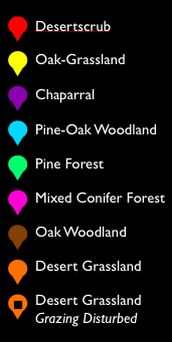
In each biome, 100-m long transects were placed farther than 0.25 km from the road, to minimize possible road effects. On the south side of the range we established five transects in Desertscrub (at elevations of 1045–1172 m), six in Oak-Grassland (at elevations of 1384–1433 m), seven in Pine-Oak Woodland (at elevations of 1803–2422 m), two in Chaparral (at elevations of 1923–2052 m), and eight in Pine Forest (at elevations of 2224–2463 m). On the north side of the range we established seven transects in disturbed Desert Grassland (historically grazed areas at elevations of 1323–1451 m), six in relatively undisturbed Desert Grassland (at elevations of 1330–1645 m), two in Oak Woodland (at elevations of 1939–2000 m), five in Pine-Oak Woodland (2032–2149 m), five in Chaparral (at elevations of 1845–1971 m), and four in Pine Forest (at elevations of 2218–2305 m). Ten transects in mixed conifer habitat were established in the Mt. Lemmon and Mt. Bigelow areas (at elevations of 2442–2777 m).
|
|
| Moore Lab at The University of Arizona Arthropod Systematics |
|
